
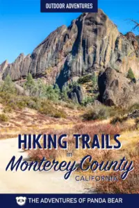
Monterey’s hiking trails are some of the best in the state of California, we’ve compiled 10 of the best Monterey hiking trails for you to explore. The hiking in Monterey County is especially great because the county has got a little bit of everything. From waterfalls along the Pacific Ocean, redwoods in Big Sur, and rock formations inland, you’ll find amazing views along every hike in the Monterey area.
Plus, if you’re hiking in the Monterey area, there’s a good chance you’ll see some wildlife! Along the coast there are opportunities to spot sea lions, sea otters, and various sea birds. In the redwood forests, you might happen upon a banana slug or two. And inland, you might find lizards or other creatures.
HEALTH ADVISORY: Note that while Monterey County is now open to visitors, they are now asking visitors to travel responsibly. Face coverings are required throughout the state. The county is also pushing social distancing (staying at least 6 feet away from others), staying home if you feel sick, and leaving no trace behind. For more information, please see website.
This is our list of 10 best hiking trails in Monterey!
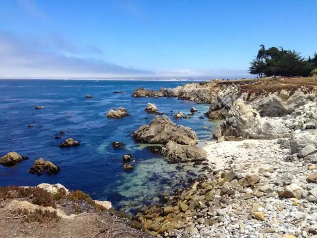
Table of Contents
Monterey Bay Coastal Recreation Trail, Castroville to Pacific Grove
The Monterey Bay Coastal Recreational Trail is an 18-mile long trail that runs from Castroville down to Pacific Grove. It’s also one of the most popular trails in Monterey since it traverses popular tourist spots including Old Fisherman’s Wharf, Cannery Row, and the Monterey Bay Aquarium, making it very accessible if you’re already in the area.
Our favorite part of the trail is walking from Old Fisherman’s Wharf in Monterey to Lovers Point Park in Pacific Grove. It is approximately 2.2 miles in one direction, making it a 4.4 mile walk in total. For a shorter hike, you can also walk from Cannery Row in Monterey over to Lovers Point Park. This is a little bit shorter and clocks in at 1.5 miles one way and 3 miles total.
Best Time to Hike this Trail
Spring is best for this trail if you’re wanting to see wildflowers in bloom. The ice plants are located between Pacific Grove and Asilomar State Beach. You’ll spot this pink, technicolor treat between the months of April and May.
For wildlife, you’ll be able to see harbor seals between the months of March and July. This is pupping season and though you can’t and shouldn’t get close, you might catch a glimpse of the famous harbor seals of Pacific Grove on your hike.
Trail Length
18 miles from Castroville to Pacific Grove
5.2 miles from Old Fisherman’s Wharf to Asilomar State Beach
2.2 miles from Old Fisherman’s Wharf, Monterey to Lovers Point Park, Pacific Grove
1.5 miles from Cannery Row, Monterey to Lovers Point Park, Pacific Grove
Elevation Gain
554 feet
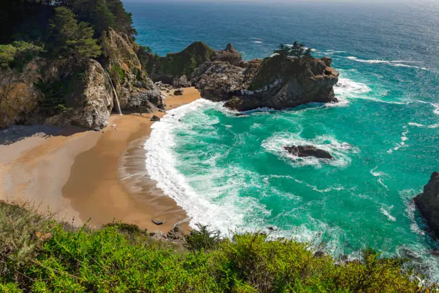
McWay Waterfall Trail, Julia Pfeiffer Burns State Park, Big Sur
Located within Julia Pfeiffer Burns State Park, McWay Waterfall Trail is one of the most popular coastal hikes in the Big Sur area. Its scenic cliffside waterfall makes it a particularly beautiful and unique hike.
The hike takes you to an overlook where you can see the waterfall flowing into the Pacific Ocean via the beach. The trail is paved and wheelchair accessible, taking you through a tunnel, under the highway, and to the observation deck.
Important Note: You used to be able to hike down closer however due to erosion the remainder of the trail is now unsafe and closed so there is no access to McWay Beach.
Best Time to Hike this Trail
Spring and summer are the best times to take this trail. During the spring and sometimes summer, you’ll get a chance to see some yellow wildflowers.
Trail Length
1.1 miles to the observation deck and back
Elevation Gain
170 feet
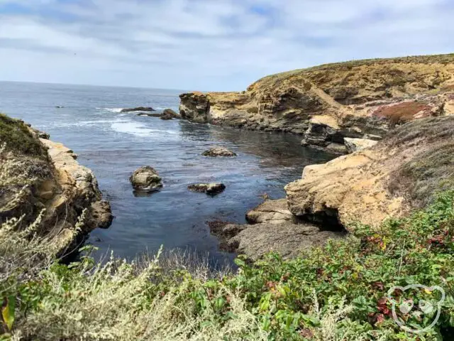
Soberanes Point and Whale Peak Trail, Garrapata State Park, Carmel-by-the-Sea
Located just south of Carmel Highlands, Garrapata State Park is very close to Carmel-by-the-Sea and is home to great trails traversing from the rocky coastline to the redwood forests. Soberanes Point and Whale Peak Trail is a great 1.8 mile loop on Soberanes Point with scenic views and wildflowers.
The hike is pretty easy and you’ll easily spot wildlife from sea otters to harbor seals, sea lions and even whales. Portions of the Soberanes Point Trail, namely, the parts closer to Hwy-1 (Pacific Coast Highway) along the side of Whale Peak, do have a few sets of stairs so be prepared for that.
Best Time to Hike this Trail
Yet another trail with beautiful wildflowers, spring and summer are the best times to take this trail to see those. However with the amazing views of the Pacific Ocean, any time is a good time as long as the weather is clear!
Trail Length
1.8 miles loop
Elevation Gain
311 feet
Fort Ord Dunes State Park Loop Trail, Fort Ord Dunes State Park, Marina
This trail along the beach at Fort Ord Dunes State Park takes you on a paved path and then onto the beach. It’s a great spot to walk, bike, or even just to explore the sand dunes and of the Monterey coast. Towards the end of the trail you’ll also find bunkers from when the area housed Fort Ord.
Fun Fact: Fort Ord Dunes State Park was once a United States Army installation housing 15 rifle stations along the beach and the grid you see in the sand dunes was once used as a firing range. The fort was in use between 1917 and 1994.
The hike is a leisurely walk though you might find that it can be a bit more of a struggle once you hit the sandy parts.
Best Time to Hike this Trail
Spring, obviously, for the ice plant flowers!
Trail Length
4.1 miles loop
Elevation Gain
265 feet
Point Lobos Loop Trail, Point Lobos State Reserve, Carmel-by-the-Sea
Point Lobos Loop Trail is obviously located within its namesake Point Lobos State Reserve. This hike is a combination of multiple trails for a total of 5.1 miles including Point Lobos, N Shore, Cypress Grove, Sea Lion Point, Sand Hill, S Shore, Bird Island, S Plateau, Carmelo Meadow, and Granite Point Trails. The route will take you to wonderful lookouts such as Cannery Point, Guillemot Island, Sea Lion Point, Weston Beach, China Cove, and more. Our recommended trail route is to start at the parking lot at Whaler’s Cove and making a big loop along the coast in a counter-clockwise direction.
Fun Fact: Point Lobos gets its name from its Spanish name, “Punta de los Lobos Marinos,” or “Point of the Sea Wolves” due to the sound of the sea lions nearby.
Some of our favorite parts of this trail include spotting wildlife, we’ve gotten a chance to see sleeping sea lions, lizards, and of course, all of the sea birds that make their homes along the rocky coast.
Be sure to also check out Whaler’s Museum, you can check out the giant whale bones to the side of the museum building and various artifacts that once turned whale blubber into oil.
Best Time to Hike this Trail
During the spring and the fall, the coast is less foggy compared to the summer and you’ll be treated with better views. We visited in mid-August and even though it was technically during the summer, we did catch some sun once the fog burned off.
Trail Length
5.1 miles loop
Elevation Gain
348 feet
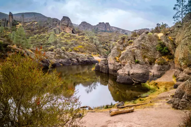
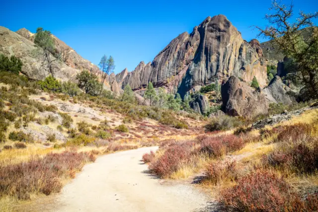
Moses Spring Trail to Rim Trail Loop, Pinnacles National Park
Important Note: Many trails are closed due to wildfires, click here for more details.
We can’t talk about the hikes in Monterey County without talking about Pinnacles National Park, the Monterey area’s one and only national park!
When you think of Monterey, you might think of beautiful blue water and rocky coastlines and you’re not wrong about that at all as you’ve seen from the trails we’ve already recommended. However, Pinnacles is located inland, in a mountainous area east of the Salinas Valley. Many of its rock formations were created through volcanic activity with magma depositing above granite forming a vast volcanic field.
Fun Fact: Pinnacles National Park was established as a national monument in 1908 by President Teddy Roosevelt and didn’t become a national park until President Barack Obama in 2013.
The trail starts at the parking area at Bear Gulch Day Use Area, you can take the Moses Spring Trail through the Bear Gulch Trail and out via Rim Loop. This is a great trail to easily see beautiful rock formations, the caves of Pinnacles National Park, and the Bear Gulch Reservoir all in one trail.
Best Time to Hike this Trail
During the summer this trail can be extremely hot, spring and fall tend to be the best for prime weather and comfort.
Trail Length
2.2 mile loop
Elevation Gain
500 feet
Condor Gulch Trail to High Peaks Trail Loop, Pinnacles National Park
If you have the entire day and are down for a more strenuous trail, the Condor Gulch Trail to High Peaks Trail loop is one of the best in all of Pinnacles National Park. Note that parts of the trail can be super steep and narrow, especially in the High Peaks section.
To see more of the park, you can also add on the Rim Trail and Moses Spring Trail on the way back to make it a total of 6.1 miles and of course to see more of Pinnacles.
Best Time to Hike this Trail
During the summer this trail can be extremely hot, spring and fall tend to be the best for prime weather and comfort.
Trail Length
5.3 mile loop
6.1 mile loop when you add on Rim and Moses Spring Trails
Elevation Gain
1,300 feet
1,900 feet with Rim and Moses Spring Trails
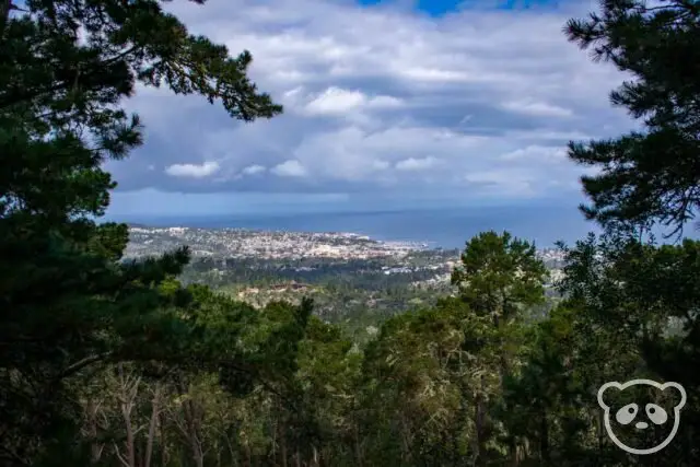
Jacks Peak Trail, Jacks Peak County Park, Monterey
Jacks Peak County Park is a great, off-the-beaten-path place to hike if you’re looking for some nature closer to the city. Located in the hills of Monterey, Jacks Peak has amazing views of Monterey and Carmel.
Fun Fact: Jacks Peak is 1,068 feet tall making it the highest point on the Monterey Peninsula.
The park has 8.5 miles of trails for you to explore. Jacks Peak trail is a quick 0.6 mile in and out hike with tall Monterey pine trees, and even wildlife like the California banana slug. If you’re up for a slightly longer hike, tack on the Skyline Nature Trail, with only 0.8 miles total,
Fun Fact: You can see Old Fisherman’s Wharf and Carmel Highlands from the top of Jacks Peak.
Along the Skyline Nature Trail, you’ll pass a rocky wall where you might be able to spot some fossilized sea creatures.
Best Time to Hike this Trail
This trail is nice any time of the year as there is some cover amongst the tall trees.
Trail Length
0.6 mile in and out
0.8 mile loop with the Skyline Nature Trail
Elevation Gain
121 feet
Ollason Trail, Toro Park, Salinas
Important Note: This park is completely closed due to the River Fire, click here for more details.
Toro Park in Salinas Valley has some of the best trails in all of Monterey County, one of these amazing trails is the Ollason Trail. This hike is a bit strenuous and takes you to the top of Ollason Peak, at 1,800 feet. Along the way you’ll pass by beautiful trees and even grazing cattle.
Best Time to Hike this Trail
Spring and fall is the best time to hike this trail as there is minimal cover on the trail.
Trail Length
8.2 mile loop
Elevation Gain
1,007 feet
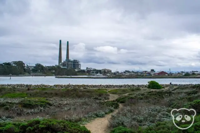
Moss Landing State Beach Loop, Moss Landing State Beach
This is an easy walk along the beach between the sand dunes and the Monterey Bay towards the mouth of Elkhorn Slough.
Fun Fact: Elkhorn Slough is one of the largest estuaries in California. It is home to over 700 marine species including mammals, birds, fish, invertebrates, algae, and plants.
Elkhorn Slough is also a great place to watch the birds and get a glimpse of wildlife in the area. It is home to California’s largest concentration of sea otters so you could easily spot one from the shore.
Best Time to Hike this Trail
In the summer, there might be quite a bit of coastal fog, fall and spring are more ideal weather wise. We visited in early March and it was a bit overcast and rainy.
Trail Length
4.1 mile there and back
Elevation Gain
65 feet
Monterey County’s amazing hiking trails run from coastline with marine wildlife and redwoods to grassy valleys with cows, volcanic rock formations in Pinnacles National Park and views of the Monterey Peninsula. You’ll be able to find a trail that suits any type of scenery you’d want to see.
List of the Hiking Trails in Monterey, California
- Monterey Bay Coastal Recreation Trail, Castroville to Pacific Grove
- McWay Waterfall Trail, Julia Pfieffer Burns State Park, Big Sur
Parking lot located off of Pacific Coast Highway, Hwy-1
GPS Coordinates: 36.158879, -121.670312 - Soberanes Point and Whale Peak Trail, Garrapata State Park, Carmel-by-the-Sea
25070 Cabrillo Hwy, Carmel-By-The-Sea
GPS Coordinates: 36.452087, -121.925685 - Fort Ord Dunes State Park Loop Trail, Fort Ord Dunes State Park, Marina
Parking lot located off of Beach Range Road, Marina
GPS Coordinates: 36.660195, -121.820966 - Point Lobos Loop Trail, Point Lobos State Reserve, Carmel-by-the-Sea
GPS Coordinates: 36.520077, -121.940858 - Moses Spring Trail to Rim Trail Loop, Pinnacles National Park
East Entrance at Pinnacles Visitor Center
GPS Coordinates for East Entrance: 36.493545, -121.146646
Parking lot located at Bear Gulch Day Use Area
GPS Coordinates for Bear Gulch Day Use Area: 36.481145, -121.181603 - Condor Gulch Trail to High Peaks Trail Loop, Pinnacles National Park
East Entrance at Pinnacles Visitor Center
GPS Coordinates for East Entrance: 36.493545, -121.146646
Parking lot located at Bear Gulch Day Use Area
GPS Coordinates for Bear Gulch Day Use Area: 36.481145, -121.181603 - Jacks Peak Trail, Jacks Peak County Park, Monterey
25020 Jacks Peak Park Rd, Monterey
GPS Coordinates: 36.564327, -121.874638 - Ollason Trail, Toro Park, Salinas
501 Monterey-Salinas Highway 68, Salinas
- Moss Landing State Beach Loop, Moss Landing State Beach, Moss Landing
Parking located on Jetty Road, Moss Landing
GPS Coordinates: 36.805559, -121.788799
Map of the Parks and Parking Lots for the Best Hiking Trails in Monterey, California
Loved this guide to the 10 Best Monterey Hiking Trails? Pin it for later!

")
")
12 Comments
I think I would absolutely love hiking here. That blue, blue sea against the jagged rocks looks gorgeous & then The Pinnacles looks totally unique.
Honestly we think Monterey County has some of the most beautiful spots along the California coast 😉
These hikes look so beautiful! Pinnacles National Park was not high on my bucket list, but now it is! Thank you for sharing!
Hiking in the Monterey area is truly amazing and a wonderful experience.
We had a CA road trip planned to San Fran from SoCal this summer but had to cancel! These are great places for us to stop along the way!! Thanks so much for sharing! Pinned for us for later!
Oh well, hope you’ll get a chance to visit soon.
Great list! Monterey makes a great base camp for exploring the western side of Pinnacles NP. The High Peaks trail is one of my favorites, too!
It does indeed! Pinnacles is definitely one of the most underrated national parks in the state.
What a great list of hikes! Can’t wait to try all of them once I can travel to California. Thanks for putting this together, I’ll definitely save it for future reference.
There is so much hiking in California, don’t make us keep you only to Monterey County! 😉
Absolutely stunning! I will definitely do this hike.
There are so many hikes you can do in Monterey County! This is just a handful of them.